We can see through crystalline skies its unique beauty and something of its expanse from 8,000 feet—a flat, bright-green flood plain pocked from horizon to horizon with black-water lakes and ponds in myriad sizes and shapes, round, oblong, new-moon crescents beneath the wing, and away to the west, chevrons, hearts and playing-card clubs, too many and various to describe or absorb—on the approach to Cherskiy’s gravel airstrip. And then, just before touch down, we cross the unmistakable three-kilometer-wide Kolyma River. Sergei Zimov, founder and director of the Northeast Science Station, and his son Nikita greet us in front of the dilapidated terminal, embracing those members of the Polaris Project who have been here in previous years. Groggy, jet lagged and, for those of us who’ve not been here before, a bit confused, we load our huge mound of science and personal gear aboard a flatbed truck for delivery to the station. We’ve traveled better than halfway around the globe, through fifteen time zones, twenty hours in the air, nearly as many waiting in airports, and now we’re here, delighted, if disoriented.

Aerial view of the lake-studded Siberian landscape. © Becky Tachihara
“Here” is 68.7 degrees North latitude by 161.3 degrees East longitude, over 120 miles above the Arctic Circle, near where the Panteleikha River joins the Kolyma. Max Holmes, our chief scientist, metaphorically equates the flow of rivers to that of blood in the human body. Just as doctors can learn the state of a person’s health by measuring blood chemistry, scientists can measure river chemistry to determine the state of the river and the watershed it drains. There are four larger rivers than the Kolyma by volume of transport in the Siberian Arctic, all of which empty into the Arctic Ocean. But the Kolyma is the largest river in the Arctic (and so the world) that flows exclusively over permafrost. This matters a lot, since the central scientific purpose of our journey to Siberia is to measure the transport of carbon from the land via the river to the ocean. It sounds simple said that way.

Map of the Kolyma River region. © Becky Tachihara
It would be handy if carbon in all its forms washed straightforwardly into the Kolyma River and then flowed cooperatively downstream past the Northeast Science Station to be measured by our scientists waiting with the big-river version of a syringe to extract samples for analysis. Then after a few years of measurements to factor out seasonal and other natural variations, scientists could tell us whether or not the permafrost was stable and all that carbon stored therein was safe from degradation and subsequent exposure to the atmosphere. But like much else in natural science, it’s not that simple.
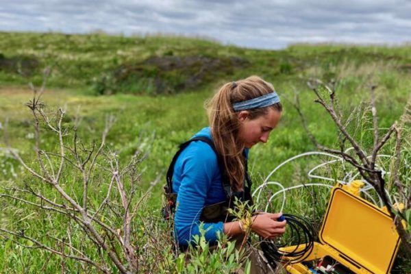
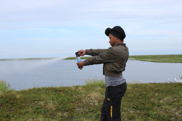
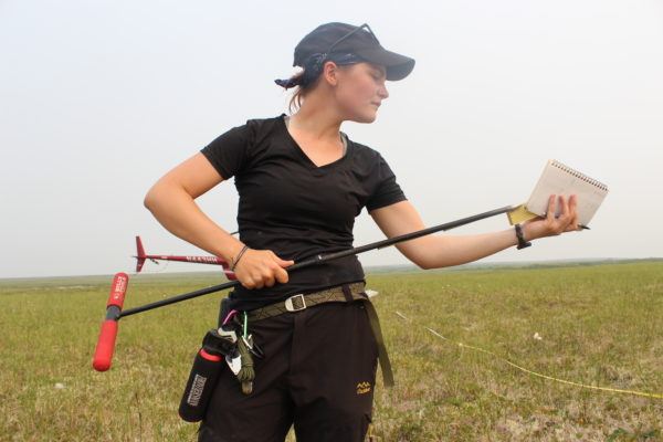
The big river has multiple tributaries all of which transport carbon, and these are fed in turn by progressively smaller tributaries until we get down to trickling forest streams each transporting carbon toward the Kolyma. It would be far easier and simpler to measure the system if scientists could ignore the tributaries on the grounds that they all combine somewhere upstream ultimately to flow into the Kolyma thence past the station where our scientists wait to measure its carbon and other chemical transport. The trouble is this method is simplistic, because various processes transform the carbon en route to the big river. Bacteria feed on the carbon in the streams, producing carbon dioxide, which is then “outgassed” into the atmosphere. So our student scientists need to tromp deep into the larch forest, never mind the mosquito swarms, to sample and analyze stream water if they are to understand the aquatic processes. That also sounds simple. You just pull on your boots, bug shirts, and head nets and go collect your water samples for later analysis back in the labs. The trouble is the aquatic system, though vitally important, is only one arc in the carbon cycle. We’ll still need also to measure the standing stocks of carbon in the terrestrial environment, in trees and in soil in order to understand how carbon moves through the entire watershed on its way to tidewater.

The Kolyma River. © Becky Tachihara
Nature loves circles. Things that go around and around conserve mass and energy. The ultimate scientific objective is to understand the cycles in the ocean, on land, and in the atmosphere in their entirety and, further, to understand how the cycles are braided together. (For instance, scientists discovered global warming only when, during the 20th century, they began to communicate across disparate disciplines of oceanography, astronomy, botany, biology, etc.) However, given the complexity and the variations in the carbon cycles, scientists need to sort of disassemble the unity they all recognize to exist and specialize in a particular segment of the whole. Our principal investigators (PIs,) leaders of the Polaris Project, specialize individually in river, stream, soil, lake, and forest ecology, but they probably wouldn’t object if we say that what unifies their work is a focus on watershed ecology. Further, we could say that they and the students they mentor seek to understand the present state of the environment in order to understand how it’s changing and perhaps how it will change in the future. That’s a pretty good definition of the Polaris Project itself.

Hiking through the Siberian landscape. © Becky Tachihara
* * *
To most people unfamiliar with it, the “Arctic” suggests constant cold, even ice, but that’s far too monochromatic in fact. Though this region of northeast Siberia lies beyond the Arctic circle, it’s climate is typically continental, characterized by seasonal extremes, as opposed to coastal climates moderated by ocean influence. It’s a gorgeous day, cloudless, clear, and almost hot. The fine morning breeze that riffled through the larch tree branches with a sound like flowing water has lightened this afternoon, and the mosquitoes are taking advantage of the calm. From the hill above the river where the red-hull barge, home to our thirteen students, is moored, you can see forever in all directions across the green and watery floodplain. It’s a gorgeous sight. All looks well from this vantage point, an environment in sublime balance. But it’s not in balance. The Arctic is out of joint. Any literate, aware person knows that. But scientists, professional skeptics, don’t speak in such language. They need to put numbers to the changes. They need to measure the present before they would presume to predict the future. That’s why we’ve traveled halfway around the world to the Northeast Science station.