
I’ve been to Siberia hundreds of times, maybe even thousands. Sometimes making several trips in the very same day. I’ve seen its seasons, good weather, bad weather, the mountains and valleys, rivers, ponds, lakes, and wetlands. I’ve visited each of the great Arctic rivers of Siberia, wondered at permafrost features, and even explored forest fire burn scars.
But the problem is, however, I’ve never… ACTUALLY… ever been to Siberia. Until now, each of my prior visits has only been in the virtual world, through our growing archive of geospatial and satellite data. I’ve worked on the Polaris project now as a Geographic Information Systems specialist and spatial data manager since the early days of the project — almost 6 years. I’ve built hundreds of maps, processed terabytes of data, contributed to websites, books, and videos. I’ve even built a data repository for guests and project participants. The problem remains, however, that I’ve never actually visited the study site. To date, all that I know about Siberia is in the format of 1’s and 0’s… binary data, and nothing else. I’ve been told that the tundra is beautiful, but in the satellite imagery it doesn’t seem much more attractive than the boreal forest, or the adjacent uplands. I’ve been told that the bugs really suck, but they’re too small to put on a map and they move too quickly to build a point-cloud dataset. So for me, they’ve yet to exist.
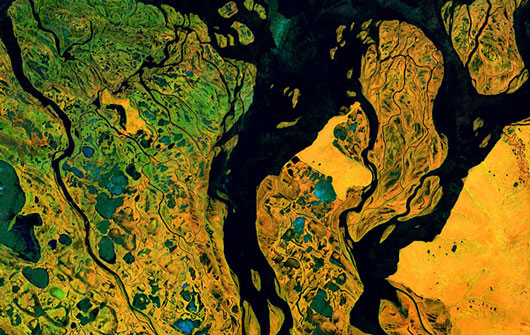
Satellite’s-eye view of the Kolyma.
I leave for my first REAL trip to Siberia in just two days. I’m looking forward to working with this year’s group on geospatial related data acquisition, management, and modeling activities. From many other field trips in the past, I’ve learned that there is true inspiration in taking the time to travel to the study site. It allows me to build relationships, both with project participants and with the locals. It also gives me the chance to make connections between my, now very elaborate, virtual world and reality. And, yes, maybe even suffer a bug bite or two.
There’s a huge demand for those of us with spatial skills these days in the world of Earth system science. But if I have the chance to choose between a project that’s just a pile of data, and one that has relationships, smells, memories, adventure, and stories. I’m most definitely going to choose the latter.
For now, I wonder if the water in the Kolyma is as dark as it is in my satellite image.
Comments(5)-
-
-
-
-
Elena says
June 27, 2014 at 5:30 pmI understand this sentiment and appreciation of travel well. Travel safely and enjoy the surprises it brings! Leave the bugs there, though.
Max Holmes says
June 29, 2014 at 10:07 amWe’ve been trying to get Greg Fiske to the Kolyma for several years now, but each time we had problems with schedules or funding. Well, I guess we had these same problems this year – in fact they are perpetual problems – so we finally just decided to go for it. Greg has been a fantastically important member of the Polaris Project team and I’m really excited to see how his prospective changes after finally experiencing the Kolyma!
Max Holmes
Jorien Vonk says
June 29, 2014 at 10:33 amHave fun Greg!!
Kathy says
June 30, 2014 at 4:43 amI agree that real life interactions is the best choice of working on a project. It beats piles of data any day. The knowledge gained from interacting with the locals is priceless. Have fun, be safe, learn well.
Paul Mann says
July 3, 2014 at 5:08 pmAbsolutely thrilled that you get the chance to finally go to our sites and see the places that you have helped me (us) to map and study over the last few years! Gutted that I can’t be with you trekking Y4 and hunting down the next secret to find. Enjoy the experience Greg, you deserve it (+ I have lots of GIS related questions to ask you…)
Hope everyone is doing well and settling in. Don’t eat all the squid…. I”l be there in September! Good luck team, Paul Mann